
Milton ZIP Directory Coverage
Milton uses several postal identities, but each address must be checked on its own. Official city examples confirm 30004 and 30009 within Milton, while a city economic-development source includes 30075 at the Roswell edge. The city also once listed 30169 as Canton, an anomalous value that should not be treated as verified USPS coverage.
| ZIP | Milton areas covered | Postal label | Search note |
|---|---|---|---|
| 30004 | Crabapple, City Hall, and broad rural or residential territory | Milton or Alpharetta usage | Main Milton ZIP, but its ZIP area extends outside city limits |
| 30009 | Highway 9, Deerfield-side Milton, and Providence Park | Alpharetta | An Alpharetta mailing label can still be inside Milton |
| 30075 | Roswell-side edge or regional territory | Roswell | Verify the specific address with USPS and Milton GIS |
| 30169 | Not verified | City page called it Canton | Likely anomaly; do not claim it as Milton coverage |
A ZIP code directory is a routing aid, not a resident roll. It narrows a large search area and helps explain why the same road can carry more than one postal label. It cannot decide whether a property is incorporated into Milton.
Verify a Milton ZIP First
The safest sequence uses two official systems. USPS answers the mailing question. Milton's My Milton Info or City Map answers the municipal question. The assessor then anchors the physical parcel by situs address or PIN.
- Enter the complete street address in the USPS ZIP Code Lookup. Preserve the standardized postal city and ZIP.
- Search the same address in Milton On Demand to check city inclusion and map context.
- When a road lies near a boundary, inspect its City Left, City Right, ZIP Left, and ZIP Right centerline values.
- Open the Fulton assessor by situs address or parcel ID. Keep the owner mailing field separate.
- Use an official record's documented ZIP field only after these checks agree on the intended parcel.
This two-step postal and city check is essential around Highway 9, Deerfield, and the Roswell edge. It also prevents a 30004 result outside Milton from being counted as a city resident record.
USPS Starts Milton ZIP Lookups
The official USPS form is the primary address-to-ZIP source for the Milton ZIP code directory. It expects a deliverable street address rather than a neighborhood name or city-boundary guess.
The USPS address lookup screen shows the required starting point.
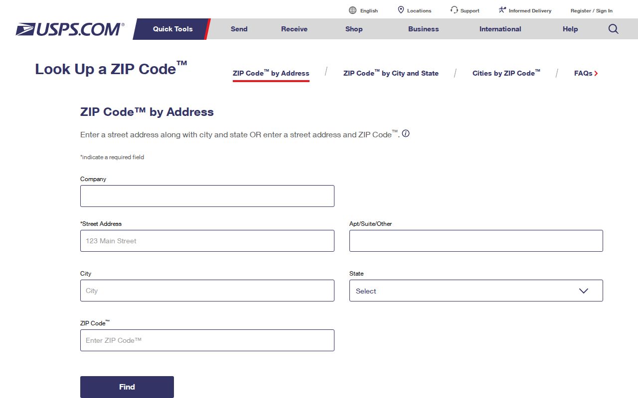
The result should be carried into the city map and assessor, because USPS standardizes mail delivery and does not certify incorporation into Milton.
| Lookup field | What to enter |
|---|---|
| Street address | The full house number and road name |
| Apartment or suite | The unit when the address has a subaddress |
| City and state | The known postal city plus Georgia |
| ZIP result | Save the standardized five-digit code and any ZIP+4 returned |
No exact USPS station inventory was confirmed in the research. The address result is more reliable than assigning a post office name without official support.
Alpharetta ZIP Inside Milton
An Alpharetta postal label does not place an address outside Milton. Official city examples include Providence Park at a 30009 address, and a North Main Street business with an Alpharetta 30009 mailing line is expressly within the city. This is Milton's clearest ZIP code directory quirk.
Postal labels route mail. City limits control municipal records, council districts, and Milton services. A person checking a permit, code file, or city record should use the mapped city boundary, not reject an address because the mailing city says Alpharetta. Conversely, the presence of “Milton” on a mailing line does not prove the parcel is incorporated.
Boundary check. Confirm the USPS result and Milton city map separately; each answers a different question about the same address.
Why Milton 30004 Runs Wide
The 30004 postal area is larger than the City of Milton. Census ZIP Code Tabulation Areas also approximate postal geography and should not replace city population figures. Milton recorded 41,296 residents in the 2020 Census, up from 32,661 in 2010, while the broader ZIP territory includes places beyond the city.
That growth period brought substantial new construction and parcel change. It does not mean every new subdivision seen under 30004 is in Milton. Check incorporation and parcel geometry before using a ZIP result to choose the city custodian. Crabapple is a civic core within Milton, while Birmingham, Bethany, and other rural areas may have wide parcels and fewer sequential addresses.
Note: ZIP-wide statistics and city statistics measure different geographies, so their totals should never be merged without a boundary method.
Search Milton Records by ZIP
Most official sources are not built as a ZIP-wide people search. The assessor accepts owner, address, or parcel routes. Fulton and Milton GIS provide ZIP context around parcels and street centerlines. The ordered Georgia voter file includes residence and mailing ZIP fields, but My Voter Page checks only one known voter and requires identifying details.
Use these record keys in their proper order:
- USPS deliverable address and ZIP for mail routing.
- Situs address and PIN for the physical Fulton parcel.
- City map inclusion for Milton municipal jurisdiction.
- Owner mailing ZIP for tax correspondence, kept separate from situs.
- Voter residence ZIP only within a lawfully obtained registration file.
Georgia's Open Records Act does not require Milton or Fulton County to create a new ZIP-by-ZIP resident compilation. Ask for an existing record with a known field and date range instead. A purchased voter file has noncommercial-use limits and omits unregistered residents and protected addresses.
Milton ZIP Values by Road Side
Milton GIS centerlines store address ranges, city values, and ZIP values for both sides of a road. Those fields explain a hard case: two nearby parcels can face the same street while falling in different postal or municipal areas. Search the actual address point and parcel polygon rather than applying one road-wide label.
The city's E911 address points distinguish main situs addresses from suite or building subaddresses and are revised over time. Parcel descriptions add land lot, district, subdivision lot, block, and plat. These identifiers remain useful when a road name, number, or postal label changes.
Once a ZIP has narrowed the area, use the Milton street directory for parcel-by-parcel work. It follows each situs address into ownership, deed, permit, and lawful voter evidence.
Milton Postal Names Through Time
Present-day Milton city records begin in December 2006. Earlier addresses may be cataloged under unincorporated Fulton County or an Alpharetta postal heading. Farther back, former Milton County existed from 1857 through 1931 and merged into Fulton in 1932. The old county name described a jurisdiction, not today's municipal boundary.
Transportation also changed the record landscape. Highway 9 developed in the 1920s era, while Georgia 400 opened in stages from 1971. Later plats, suburban development, address points, and permits are more common along growth corridors. Older rural property may be easier to trace through land lots, deeds, churches, cemeteries, and historic crossroads such as Crabapple or Birmingham.
A Milton ZIP code directory should therefore preserve the label printed on each source. Silently replacing an old Alpharetta or Fulton heading with “Milton” can hide where the record was actually filed.
Milton ZIP Directory Terms
Postal terms describe delivery structure. They do not describe city government or prove where a person lives. These definitions keep the ZIP code directory from carrying more weight than it should.
- ZIP code
- A five-digit USPS code used to route mail to a delivery area.
- ZIP+4
- The five-digit ZIP plus four added digits that narrow mail to a block, building, or delivery segment.
- PO-box ZIP
- A ZIP used mainly or solely for post-office boxes rather than normal street delivery.
- Unique ZIP
- A ZIP assigned to one high-volume organization or facility.
- Carrier route
- A group of addresses served by one postal delivery route.
No Milton PO-box-only or unique ZIP was verified in the official research, so none should be inferred from a five-digit result. Carrier routes can cross boundaries and are not household lists.
ZIP Codes Versus Milton Limits
ZIPs and city limits are built for different purposes. Milton's municipal boundary decides which city office may hold permits, code cases, council records, or other post-2006 files. USPS decides the preferred mailing line. Fulton County remains the keeper for parcels, deeds, many courts, and elections across both postal and city boundaries.
Use the ZIP code directory to narrow geography, not to claim residence. Property owners may live elsewhere. A registered address can be protected or out of date. A voter file does not list every household member, and an assessor has no renter roster. The anomalous 30169 listing is a reminder to verify rather than repeat an unsupported code.
Use precise claims. A verified ZIP identifies mail geography; only a separate Milton boundary check establishes city jurisdiction.